


WebRuss
Well-Known Member
- Joined
- Jun 14, 2013
- Messages
- 990
- Reaction score
- 199
The Perfect US Flying Trip?
I am sure that many of you have seen this article about the Perfect US Road Trip. I really enjoyed the article and recommend giving it a read. Lots of great suggestions for places to visit and things to see.
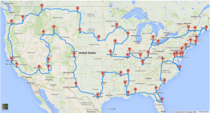
After reading it, I got an idea. What if I did this same trip in my airplane? I pulled up the road map provided in the article and starting matching it up to airports using the SkyVector website. Lo and behold, nearly every place mentioned has an airport nearby. In some cases right next to the site. I created a flight route that nearly mimics all the locations provided in the perfect trip and to be honest it looks quite possible. Maybe a few adjustments for getting over mountains and around some restricted areas but, otherwise very possible.
I used airnav.com to help me find airports close to the sites. When selecting airports I tried to go with local or municipal airports that had FBOs that could get a rental car or at least provide a courtesy ride to a local hotel. In nearly every case fuel and hotels were available within a short drive, if an overnight stay was needed. Mind you, not every place had a five star hotel with every amenity, but most had inexpensive motels within a short distance. I did not really focus on finding the least expensive fuel, just that the airport had fuel available. I am sure a thrifty pilot could use airnav.com to check local fuel prices and adjust the route to save a buck or two on fuel.
Could this route be optimized to be more direct? Yes it can. The goal here was to match the road trip as close as possible. That way even if you don’t land in every state you at least get to fly over and see them from the air. Another benefit is that you can fly over all those commuters on the highways below, open your window and shout at them “Where is your plane peasant!”.
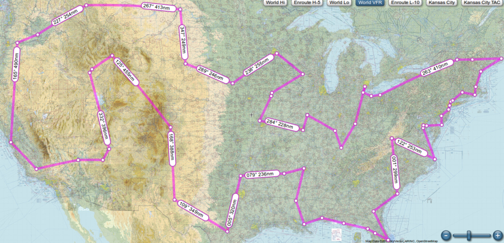
As this is supposed to be a sight seeing trip I chose to plan for flying my 1964 Cessna 172D. This will be a low and slow flight focusing on maximum visual enjoyment. This plane consumes about 6-8 g.p.h and goes about 105 knots (or 120 mph) on a calm wind day. The trip would cover 9673 nm, take 91.5 hours of flying time and consume at least 778.3 gallons of fuel. Some of the legs would be right at the maximum range with safety, and to be honest I’m not sure my backside or bladder could make it that far without an interim stop. On some of the legs slight left or right deviation would be advisable to avoid those pesky tall mountains, but none of it is impossible.
If I did this trip in my Piper Comanche, slightly different numbers. 80.5 flight hours and 804 gallons of fuel. For sure I would be more comfortable, I could fly further and get there quicker. However I think the point is to take it all in, so low and slow would be optimal so a slower, simpler craft would be best
So who wants to go?
Happy flying
Russ
I am sure that many of you have seen this article about the Perfect US Road Trip. I really enjoyed the article and recommend giving it a read. Lots of great suggestions for places to visit and things to see.

After reading it, I got an idea. What if I did this same trip in my airplane? I pulled up the road map provided in the article and starting matching it up to airports using the SkyVector website. Lo and behold, nearly every place mentioned has an airport nearby. In some cases right next to the site. I created a flight route that nearly mimics all the locations provided in the perfect trip and to be honest it looks quite possible. Maybe a few adjustments for getting over mountains and around some restricted areas but, otherwise very possible.
I used airnav.com to help me find airports close to the sites. When selecting airports I tried to go with local or municipal airports that had FBOs that could get a rental car or at least provide a courtesy ride to a local hotel. In nearly every case fuel and hotels were available within a short drive, if an overnight stay was needed. Mind you, not every place had a five star hotel with every amenity, but most had inexpensive motels within a short distance. I did not really focus on finding the least expensive fuel, just that the airport had fuel available. I am sure a thrifty pilot could use airnav.com to check local fuel prices and adjust the route to save a buck or two on fuel.
Could this route be optimized to be more direct? Yes it can. The goal here was to match the road trip as close as possible. That way even if you don’t land in every state you at least get to fly over and see them from the air. Another benefit is that you can fly over all those commuters on the highways below, open your window and shout at them “Where is your plane peasant!”.
As this is supposed to be a sight seeing trip I chose to plan for flying my 1964 Cessna 172D. This will be a low and slow flight focusing on maximum visual enjoyment. This plane consumes about 6-8 g.p.h and goes about 105 knots (or 120 mph) on a calm wind day. The trip would cover 9673 nm, take 91.5 hours of flying time and consume at least 778.3 gallons of fuel. Some of the legs would be right at the maximum range with safety, and to be honest I’m not sure my backside or bladder could make it that far without an interim stop. On some of the legs slight left or right deviation would be advisable to avoid those pesky tall mountains, but none of it is impossible.
If I did this trip in my Piper Comanche, slightly different numbers. 80.5 flight hours and 804 gallons of fuel. For sure I would be more comfortable, I could fly further and get there quicker. However I think the point is to take it all in, so low and slow would be optimal so a slower, simpler craft would be best
So who wants to go?
Happy flying
Russ
Last edited: